Aarhus Ådal
Distance: 7.66 Km
Hiking and bicycle routes
The marked walking and cycling routes at Aarhus Ådal provide, among other things, a connection to the protected Jeksendal. Regional routes also run through the area from Aarhus to Skanderborg and from Aarhus to Ry.
History of Aarhus Ådal
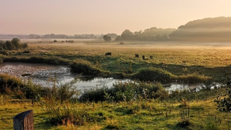
Ådalen is a valley depression located immediately west of Brabrand Lake and is part of the tunnel valley that stretches from Aarhus to Søhøjlandet in Central Jutland. To the north and south, the valley is bounded by moraine landscapes, while the northern side of the valley is intersected by Lyngbygårds Å. In the early 60s, the valley was drained and Aarhus Å relocated, straightened out and dammed, whereby great natural values were lost. The valley floor is now mainly cultivated fields as well as meadow areas and a few small forests and bog areas. The area is 358 hectares and was protected in 1983 to prevent further development, preserve the valley profile. Sludge drainage basins have been constructed in the area as part of the restoration of Brabrand Lake.
See what others are sharing on Instagram
#aarhusådal #visitaarhus #visitaarhusregion
Updated by: VisitAarhus | info@visitaarhus.com
 Photographer: @jcsvenning Copyright: @jcsvenning